When the Civil War began in 1861, Chattanooga was still a very young town going through its fair share of growing pains.
"The reason Chattanooga is many years younger than her sisters, the reason she lacks the old pillared homes of other towns, the tradition of 'Before the War' grandeur, is because the Cherokee Indians clung to the little place with desperate strength and courage. It was practically the last beautiful remnant of their once marvelous country." -- Zella Armstrong
 | |
| Looking south across the Tn. River to Ross's Landing |
Around the time that the Cherokees were ceding the last of their lands east of the Mississippi in the Treaty of New Echota in 1835, white settlers began drifting into the area in greater numbers. The fledgling settlement experienced its first growth spurt a couple of years later when it became the major embarkation point of the Cherokees on the Trail of Tears.
Almost as soon as the Cherokees were gone, the white settlers met at the log schoolhouse and voted to change the name of the settlement to Chattanooga. They soon began selling lots and laying out city streets. Nine streets ran north and south and were mainly named after trees. The central street was named Market Street. Nine streets ran east to west and were numbered.
Through some vociferous lobbying by some of Chattanooga's most prominent citizens, the town became a major railroad hub before the beginning of the Civil War. Work began on the south end of the Western & Atlantic Railroad in Marthasville, Georgia (now Atlanta) in 1839, but proceeded slowly. Eventually Chattanooga was chosen as the northern terminus of the line, and the railroad was finally completed in 1849. Chattanoogans complained that the railroad depot, on Ninth Street (now MLK Blvd.), about a mile from the waterfront, was too far on the outskirts of town, and benefited only the Crutchfields, who operated a hotel across the street. The Western & Atlantic was soon followed by the Nashville & Chattanooga Railroad (in 1854), the Memphis & Charleston Railroad (1857) and the East Tennessee & Georgia Railroad (1858), connecting Chattanooga to the rest of the United States in almost all directions.
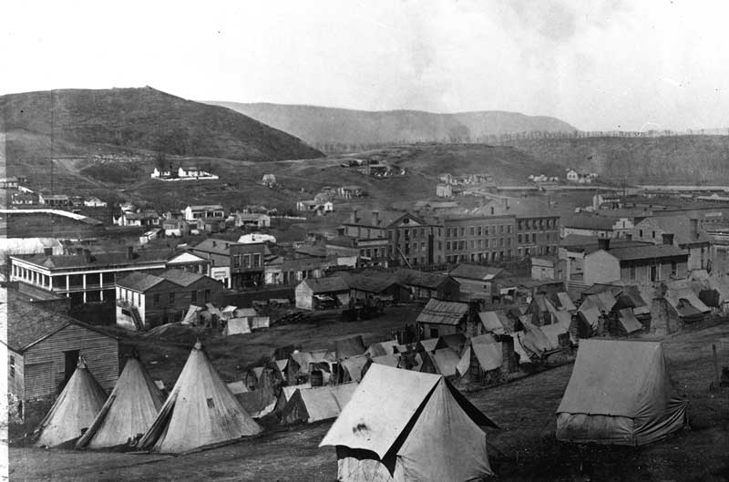 | |
| Civil War era Chattanooga |
Estimates vary, but when the war began in 1861, Chattanooga had approximately 5000 citizens. Most of the commercial activity in the town took place close to the river on Market Street. Most of the business buildings were small, one or two stories high, and unpretentious, mostly scattered on the west side of the street. The largest and fanciest building in town was the Crutchfield House, the hotel on 9th Street across from the depot. The buildings on the east side of Market Street were mostly houses. The finest houses were on the heights east of Market Street. More houses were scattered on Cameron Hill west of town.
 | |
| The Crutchfield House |
Cameron Hill is still a somewhat imposing presence west of downtown Chattanooga, looking like a miniature version of Lookout Mountain, but is vastly altered from its wartime appearance. In the early 1960s part of the east side of the hill was scraped away to make room for Highway 27 and the Olgiati Bridge. The southern portion of the ridgeline was also lowered and the top half of the hill removed.
There are a lot of hills, knolls and knobs east of town. To the south, the land is mostly flat all the way to the Georgia border.
This second map was created primarily for the purpose of marking the line of Missionary Ridge east of Chattanooga, but we can also use it to take a long view of the area.
The line of pins on the map shows the locations of Missionary Ridge's National Park Service Military Reservations and a couple of other points of interest. Missionary Ridge begins just south of the Tennessee River and meanders southward into Georgia, varying from a few meters to around 100 meters high, broken by just a very few gaps. The ridge presents a steep side rising from the plain on the west side, with undulating hills stretching to the east.
The Tennessee River takes a generally weird path. It's about 650 miles long, formed at the confluence of the Holston and French Broad Rivers in Knoxville, and flows mainly southwestward, looping through East Tennessee, into northern Alabama, where it changes direction, flowing northward, back through Tennessee and Kentucky, where it runs into the Ohio River. The river was much wilder before the Tennessee Valley Authority began constructing dams on it in the 1930s and 40s.
In the Chattanooga area, there are some interesting twist and turns. The river flows southwestward around a couple of bends until it runs into the north end of Lookout Mountain, where it makes a sharp turn to the north, carving out a generally foot-shaped section of land called Moccasin Bend at the northern foot of the mountain. The river then runs on both sides of Williams Island, then slices between Raccoon Mountain and Walden Ridge. After circling almost completely around Raccoon Mountain, it makes another couple of turns before diving southward into Alabama, passing through Bridgeport, the Union Army's supply base for most of the Chattanooga Campaign.
 | |
| Moccasin Bend from Lookout Mountain |
There is much mountainous terrain to the north and west of Chattanooga. This is respectively, the tail end of the Appalachian Mountains that dominate the eastern portion of the United States, and the Cumberland Plateau that dominates the central portion of Tennessee. Walden Ridge marks the eastern edge of the Cumberland Plateau and runs north for about 75 miles. Its highest point is Hinch Mountain, near Crossville, Tennessee. (Elevation: 929 meters)
During the siege of Chattanooga from September to November 1863, troops from the U.S. Army Signal Corps set up a post on the southernmost point of Walden Ridge. Using flags during the day and torches at night, this was virtually all the communication the besieged Union Army had with the outside world. Their outpost was called Signal Point, and the southern part of the ridge became known as Signal Mountain.
Lookout Mountain rises up from the Tennessee River. It's a long ridge that runs through the northwest corner of Georgia into Alabama. The highest point (729 meters) is in Georgia.
 | |
| Lookout Mountain |
A couple of other points of interest:
The Chickamauga battlefield is on the western side of the southernmost part of Missionary Ridge.
Farther west is the city of Ringgold, Georgia, situated in a gap of Taylor Ridge. General Patrick Cleburne fought a rearguard action here on November 27, 1863, allowing Braxton Bragg's army to escape after the Battles of Chattanooga.
No comments:
Post a Comment